Obligatory trip report for my 2020 backpacking trip to the Wind Rivers. My other trip reports are found here:
- 2019: https://frugalprofessor.com/2019-wind-river-trip-report/
- 2018: https://frugalprofessor.com/2018-wind-river-trip-report/
My two previous trips were around 40 miles over 4 days. This year, I did the following:
- Trip 1: 42 miles over 4 days with frugal brother from Big Sandy Trailhead
- Trip 2: 36 miles over 4 days with four undergrad buddies to Titcomb Basin
The two trips were separated with one day of rest. In hindsight, it was a bit ambitious. Luckily my body cooperated.
**** Key Stats for Trip 1 (Big Sandy; Cirque Loop)****
Dates Traveled: Sat 8/8/20 – Tue 8/11/20
Route:
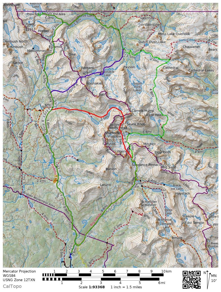
This was my third year in a year backpacking out of the Big Sandy trailhead. The first year we did the red “Figure 8” loop below. The second year we did the purple “Lazy P” loop below. This year, we did the green “Lizard Head” route below.
Caltopo map is available here link.
Elevation Profile:
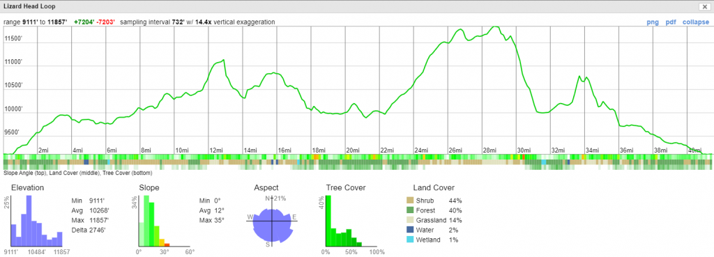
The “Lizard Head” elevation profile this year. Relative to the “Figure 8”, you replace Washakie + Texas with Lizard Head, saving a tiny bit of elevation in the process. Washakie Lake is a highlight for me so I was sad to miss it this year.
 The “Lazy P” route we did in 2019.
 The “Figure 8” loop we did in 2018.
Mileage: 42 miles over 4 days.
Weather: Almost perfect. Wind wasn’t too bad. Luckily no forest fire smoke like last year.
Bugs: Not too bad. They only came out at night.
Grizzly encounters: None.
Difficulty: The passes were tough. The flat parts were pretty easy.
Fishing: Good.
Cost: A few bucks of trail mix & Mountain House and a $300 round-trip plane ticket to Utah.
What to bring: Usual backpacking gear + bear spray + fishing pole.
Crowds: Presumably due to Covid, it was more crowded this year.
Day 1. Sat 8/8/20. 9 miles. Big Sandy Trailhead to Washakie Creek.
Left SLC and arrived at Big Sandy Trailhead (map) at 1:30pm to a thunderstorm. Hiked 10 easy miles and camped at Washakie Creek (between Marms and Skull Lakes). This is one of my favorite spots in the Wind Rivers.
Dad’s Lake. We took a few minute break to cliff jumping during a break in the rain.
Ridiculously photogenic Washakie Creek. Shadow Lake is several miles up to the right of the picture near Texas Pass.
Same spot as the other Washakie Creek pics, but looking West this time.
Day 2. Sun 8/9/20. 12 miles. Washakie Creek to Baptiste Lake to Grave Lake to South Fork Little Wind River (in valley between Loch Leven and Valentine Lakes).
North side of Haley’s Pass.
Approach to Mt Hooker / Baptiste Lake.
Fishing at Baptiste Lake. One of my favorite places on Earth.
My ambitious hiking itinerary almost killed my brother. This was the first backpacking trip of his life. He got some bad blisters but toughed it out well.
Two climbers 1/3 the way up Mt Hooker. Here’s a video of two climbers who did the 2k foot climb a few days before we arrived (link). We ran into quite a few climbers who had just completed or were about to climb Hooker. The logistics alone of climbing this mountain are impressive. I can’t imagine carrying 30 pounds of climbing gear in addition to my normal backpacking load. Mt Hooker is incredibly remote. Some choose to hire llamas/donkeys to drop stuff off to Skull Lake, but that still leaves a decent hike over Haley’s Pass to get to Baptiste/Hooker.
Camp 2: South Fork Little Wind River (in valley between Loch Leven and Valentine Lakes). There was a ton of scat in this valley where we camped. We heard elk in the adjacent forest while we were hanging our bear bags. We had a few-minute stretch in which we convinced ourselves that the strange noises were made by grizzlies.
Day 3. Mon 8/10/20. 11 miles. Washakie Creek to Lizard Head to Lonesome Lake (Circue of the Towers).
Most of this day was spent on the plateau at 12k feet. Luckily the weather cooperated perfectly. It would have been sketchy to encounter lightening while exposed that high for that long.
Almost to Lonesome Lake after a long day of hiking. Some (less frugal) people utilize llamas to haul in their gear. You can see several in the background.
Lonesome Lake in the heart of the Cirque of the Towers.
Camp 3 just South of Lonesome Lake.
Day 4. Tue 8/11/20. 9 miles. Lonesome Lake to Big Sandy Trailhead.
View of Lonesome from halfway up Jackass Pass.
Big Sandy Lake on the way out.
**** Key Stats for Trip 2 (Titcomb Basin out and back) ****
Dates Traveled: Thur 8/13/20 – Sun 8/16/20
Route:
This was my first year going to Titcomb Basin. Unlike the Big Sandy Trailhead, which requires hours of driving on unpaved (and sometimes rough) roads, the Sacred Rim Trailhead was an absolute cakewalk to drive to. It’s 30 minutes or so away from the neat town of Pinedale, WY (link). It’s paved roads the whole way.
Caltopo map is available here link.
Island Lake was our base camp from which we explored Titcomb and Indian basins.
Elevation Profile:
Only 5k ft of total elevation gain. Relatively easier than the route I’d done a couple days prior.
Mileage: 36 miles over 4 days.
Weather: Got a little cold at nights. We’d awake to frost on our tents.
Bugs: Not too bad. They only came out at night.
Grizzly encounters: None.
Difficulty: Easier than the routes I’ve done out of Big Sandy Trailhead.
Fishing: Abysmal.
Cost: A few bucks of trail mix & Mountain House.
What to bring: Usual backpacking gear + bear spray + fishing pole.
Crowds: Relative to the Big Sandy / Cirque area, it was a bit more crowded. What made it somewhat problematic is that there are much fewer good campsites in this area due to rocks & topography. Consequently, we found it somewhat difficult to find suitable campsites in this area.
Photo Credits: My buddies took many of the below pics.
Day 1. Thur 8/13/20. 9 miles. Trailhead to Seneca Lake.
Drove from SLC to arrive at the trailhead around 2:30pm. We stopped for lunch in Pinedale at Dave’s Last Stand for a glorious and relatively economical burger. Hiked 9 relatively easy miles to Seneca Lake, though the 430 ft climb to get to Seneca Lake near mile 9 was incredibly demoralizing at the end of a long day.
The 5 of us fit in a hatchback. The tallest dude is 6’6″.
Aptly named photographer’s point.
Seneca Lake. The 430ft climb to get here at the end of the day was demoralizing. As was the long hike to get water for cooking/drinking.
Day 2. Fri 8/14/20. 7 miles. Seneca Lake to Island Lake to Titcomb Basin to Island Lake.
We hiked to Island Lake and set up camp there. With day packs, we hiked to Titcomb basin. I brought a Klymit Packraft and played around in the water for a bit as others in my group fished or hiked further.
Island Lake.
Packrafting in Titcomb Basin.
Swimming hole above Island Lake.
Near campsite above Island Lake.
Day 3. Sat 8/15/20. 10 miles. Island Lake to Indian Basin to Island Lake to Hobbs Lake.
We day hiked to Indian Basin, then retrieved our stuff at Island Lake, then camped at Hobbs Lake. Finding a camping spot at Hobbs was challenging.
Once a goofball, always a goofball.
Precarious swim in Indian Basin to a little island. It was freezing.
Leaving Island Lake en route to Hobb’s Lake.
The only fish my buddy caught all trip! A trophy fish!
We did a lot of hanging bags off of cliffs this trip.
Day 4. Sun 8/16/20. 7 miles. Hobbs Lake to Trailhead.
Arrived at SLC in time to shower + catch 8:30pm flight. Landed at 11:30pm. Arrived to house around 1am.
Wrapping it up.
These trips are my therapy for the year. It’s amazing how cathartic this annual tradition is. I love how close this group of 5 former roommates from 1999 remains, despite the 2 decades that have passed since we first met. It was incredible to swap stories, share ideas, express frustrations, etc. After losing my close friend to suicide last month, it reiterated to me the importance of maintaining these special friendships. We ran into a group of friends in their 60’s who had been doing an annual backpacking trip for decades now. What a great tradition. I’m pretty sure I saw this same group on a prior trip to the Winds.
Despite having been to the Big Sandy trailhead three years in a row, I preferred that hike to the Titcomb basin hike for a few reasons: 1.) I prefer loop hikes to out-and-backs to change up the scenery, 2.) there is much more variety in the hike, 3.) it seems that there is much more solitude in the Big Sandy loops, 4.) it’s much easier to find campsites in the Big Sandy area.
Recommended gear:
- $120 6L Platypus Gravity Water Filter (link).
- $110 35°F 2lb down sleeping bag (link). Also sold by Walmart (link).
- $20/year Caltopo premium subscription (link).
- At Moosejaw you can usually get big discounts. Pair with Active Junky to get around 8-15% off of Moosejaw (as of today, it’s a 14% discount. Similar to Ebates/Rakuten but way more generous for certain things). MJ promo codes can also bring it down another 15-30%, though some of these will invalidate the Active Junky referral.
Notes to self:
Food was about perfect this year. Food list for 4-day, 3-night trip:
- Oatmeal x 3 (loaded with nuts, flax, etc)
- 1 ziplock bag of 50% trail mix + 50% unsalted mixed nuts
- 1 ziplock bag of unsweetened dried mangos
- 4 x granola bar (e.g. Rx bar)
- 4 x snicker’s bar
- Mountain house x 3
Sounds like an awesome trip! Do you have to get fishing licenses for that area?
A few buddies and I went on a backpacking trip in the Ventana Wilderness this summer and had some good luck with the rainbow trout!
If you really want to up your frugal backpacking, make the investment in a Excalibur food dehydrator. I’ve maintained and operated one almost 10 years now. You’d be amazed at how easy it is to make your own tasty meals with no additives (unlike Mountain House).
Kacy,
You do need a fishing license for WY. It’s pretty cheap though. That single minnow cost my buddy $30 with his two-day license.
I hadn’t heard of the Ventana Wilderness before, but the Google Images I found look pretty epic!
Thanks for the recommendation on the food dehydrator. As a 10-year-old child, I wanted a food dehydrator more than anything. I think I had it in my mind that I’d basically live off a diet of 100% beef jerky. In the ensuing 30 years, I haven’t thought much about a food dehydrator but I agree entirely that it could bring the food costs down to almost zero. Thanks to Costco, however, I snagged the Mountain House meals for about $4/pouch (each pouch is 2.5 servings so it’s a pretty decent meal for a hungry guy) a few years back. I bought several boxes. Unfortunately, they only seem to carry that item seasonally in the Mountain West but I was lucky enough to snag it while on vacation a few years back.